
Remembering the 1996 Kane County Flood: What You Need to Know About Flood Risks And Safety
The deadly flash flooding in the Texas Hill Country northwest of San Antonio, caused by sudden and extreme rainfall, coincides with the 29th anniversary of the worst flood in Kane County's history—the July 1996 Flood. These extreme weather events have many people asking important questions about flash floods, severe storms, and how to stay safe during such emergencies.
Over a 24-hour period from July 17–18, the southern half of Kane County saw nearly a foot of rainfall, with the City of Aurora receiving 16.9 inches in that same timeframe. Six people were killed, and the county and surrounding communities saw more than 35,000 homes damaged by floodwaters. Total flood damages were estimated at $600 million—equivalent to $1.2 billion in 2025. 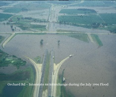
These events serve as a reminder of the serious hazards floods—especially flash floods—can pose to people, property, and infrastructure. According to the 2024 Kane County Hazard Mitigation Plan, flooding is the highest-risk natural hazard for the area. Flash flooding, in particular, ranks highest in concern based on its likelihood and the anticipated impacts across the county’s landscape.
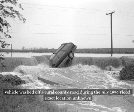
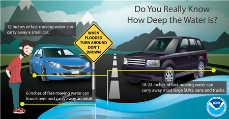
“Seeing the tragedy unfold in Texas, it reminds us how important it is for community members to stay alert during severe weather,” said Scott Buziecki, Director of Kane County’s Office of Emergency Management. “Most fatalities during flood events occur when people attempt to cross flooded roads or streets and get stuck in inundated low areas or are washed off roads by rushing floodwaters,” Buziecki added. “It doesn't take much water rushing over a road to wash away a person, car, or even a truck. The saying ‘Turn Around, Don’t Drown’ should be followed whenever a motorist comes across a flooded roadway.”
Buziecki emphasized that residents should ensure their cell phones have the Wireless Emergency Alert (WEA) system enabled, allowing them to receive emergency notices from the National Weather Service at any time of day. He also recommended having a NOAA weather radio at home as another key tool to stay informed.
“Getting weather emergency notifications when they're issued can be the difference between life and death for you or your loved ones,” Buziecki said. “We want all members of our community to be weather aware to reduce risks to people and property.”
Kane County is also using new technology and the latest GIS data to help communities prepare for both riverine and urban flood risks. These tools and maps are part of a broader effort led by the Department of Environmental & Water Resources.
“Development within the floodplains and floodways of the county's rivers and streams is regulated under the Kane County Stormwater Ordinance, which all the communities in Kane County follow,” said Jodie Wollnik, a professional engineer and Director of the Kane County Department of Environmental & Water Resources.
Following the 1996 flood, county and municipal officials collaborated and adopted the Kane County Stormwater Management Ordinance in 2002. The ordinance includes strict regulations governing how and where development can occur near floodplains associated with the county’s rivers and streams.
“We work closely with landowners and their engineers on their developments if they are near a floodplain to ensure they meet the local regulations as well as those set by the state and FEMA,” said Wollnik. “We always want to minimize encroachments into the floodplain whenever possible, and there is no building construction allowed in the floodway, which is the part of the floodplain where water flows deeper and with high velocity,” she added.
“Not all of our floodplains have been precisely mapped, particularly in more rural areas, so that is a big part of what we are addressing with the Kane County Flood Studies Initiative Project,” Wollnik said. “This project is funded through ARPA funds allocated by the County Board. It began in 2025 and is designed to address deficiencies in floodplain mapping, while also examining isolated, urban flooding issues that are not covered by FEMA but still cause significant damages and infrastructure impacts throughout Kane County and its communities.”
With recent national events in mind and the memory of historic local floods still vivid, Kane County officials encourage residents to stay aware of the resources and tools available to help them stay informed and safe during natural hazard events and weather emergencies.
For more information, contact the Kane County Department of Environmental & Water Resources at 630-232-3497 or the Kane County Office of Emergency Management at 630-232-5985.
On a statewide level, an Urban Search and Rescue (USAR) team from Illinois is headed to Texas to assist with operations after deadly flooding this week. This group of 39 rescuers from fire departments, deployed as part of the Mutual Aid Box Alarm System (MABAS) as USAR Task Force 1, will be on the ground in Texas for up to 14 days. Read more.